
Effective date: June 20, 2025
To prevent the spread of Japanese beetle in British Columbia, we have established regulated areas where the beetles have been detected.
If your address falls within a regulated area a movement certificate (PDF) is required for the movement of plants with soil, soil-related matter or growing media out of a Japanese beetle regulated area and is restricted year-round.
Description of the regulated areas for Japanese beetle
Burnaby, British Columbia
This map shows the boundary of the Japanese beetle (Popillia japonica) regulated area in the City of Burnaby, British Columbia. Starting at the point of intersection between Eastlake Drive and Production Way and continuing south until Production Way changes to Brighton Avenue; south to the three-way intersection of Brighton Avenue, Winston Street and Government Street; southwest along Winston Street to the western border of Salamander Creek; south along the western border of Salamander Creek to the northern border of the Brunette River; west along the northern border of Burnaby Lake to Still Creek; northwest along Still Creek to the Central Valley Greenway; north to Sperling Avenue; north to Lougheed Highway; east to Bainbridge Avenue; north to Broadway Street; east to Underhill Avenue; south to Eastlake Drive; and, east until the initial point of intersection between Eastlake Drive and Production Way.
Cities of Coquitlam and Port Coquitlam, British Columbia
This map shows the boundary of the Japanese beetle (Popillia japonica) regulated area in the Cities of Coquitlam and Port Coquitlam, British Columbia. Starting in the City of Coquitlam, at the intersection of the high watermark of the Fraser River and continuing west to the Coquitlam River; north to the Millennium and Garden Trail Bridges of Colony Farm Regional Park; west to Colony Farm Road; north to Access Road; west to the southern boundary of Colony Farm Regional Park; west along the boundary to Access Road; west to the western boundary of Colony Farm Regional Park; north along the boundary to Lougheed Highway; north to the point where the Coquitlam and Port Coquitlam municipal boundaries meet; northeast to Orchid Drive along the Port Coquitlam municipal boundary to the Coquitlam River; north to the point in line with Lincoln Avenue and the Port Coquitlam municipal boundary; east to the centre of Lincoln Avenue and continuing to the point where Lincoln Avenue and Oxford Street intersect; north along Oxford Street following the municipal boundary of Port Coquitlam to Mason Avenue; east to Wellington Street; south along the centre of Wellington Street following along the Port Coquitlam municipal boundary; east along the centre of Victoria Drive and the Port Coquitlam municipal boundary to the point where Victoria Drive and Cedar Drive meet; south along the municipal boundary of Port Coquitlam to the point where the municipal boundary meets Fremont Street; south to the southern terminus of Fremont Street; east to Burns Road; south to Dominion Avenue; east to the Traboulay Poco Trail and the west shoreline of the Pitt River; south along the high watermark of the Pitt River to the confluence of the high watermark of the Fraser River; west along the high watermark of the Fraser River to the initial point of intersection at the Coquitlam River.
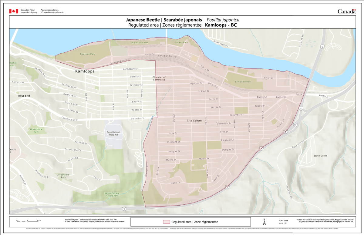
Kamloops, British Columbia
This map shows the boundary of the Japanese beetle (Popillia japonica) regulated area in the City of Kamloops, British Columbia. Starting in the City of Kamloops at the point of intersection between Columbia Street and 6th Avenue and continuing north on 6th Avenue until 6th Avenue intersects with the railway; west along the railway line until western edge of Riverside Park and Rivers Trail; following the high watermark east along the shoreline of Thompson River until the Yellowhead Highway 5; southwest along Highway 5 until Highway 5 transitions into Highway 1; west along Highway 1 until Peterson Creek; north on Peterson Creek until the south end of Glenfair Drive; north on Glenfair Drive until Columbia Street; west on Columbia Street to the initial point of intersection of Columbia Street and 6th Avenue.
Vancouver, British Columbia
This map shows the boundary of the Japanese beetle (Popillia japonica) regulated area in the City of Vancouver, British Columbia. Starting in the City of Vancouver at the point of intersection between Knight Street and East 49th Avenue and continuing west to Main Street; west along West 49th Avenue to Arbutus Street; south to the centre of Arbutus Street to West 51st Avenue; east until West 51st Avenue transitions into West Boulevard; south until West Boulevard transitions into Angus Drive; south to Southwest Marine Drive; southeast to Angus Drive; south along the centre of Angus Drive crossing West 57th Avenue to the high water mark line of the north arm of the Fraser River; following the high watermark northwest along the shoreline of the north arm of the Fraser River to the Fraser River Trail Musqueam Gateway; north to West 51st Avenue; east to Dunbar Street; north to West King Edward Avenue; east to Blenheim Street; north, crossing Point Grey Road, to the high water mark line of English Bay; northeast along the shoreline of English Bay around Stanley Park and along the shoreline of Burrard Inlet east to Commercial Drive; south to East Broadway; west to Clark Drive; southwest until Clark Drive transitions to Knight Street; south to the initial point of intersection of Knight Street and East 49th Avenue.