
These maps were produced by the CFIA for the sole purpose of visually presenting areas of Canada that were assigned a specific aquatic animal disease status for the Domestic Movement Control Program. They are not to be used for any other purpose.
On this page
- Declarations by province and marine area
- Pacific Ocean
- Pacific Ocean North and Pacific Ocean South
- British Columbia
- British Columbia North
- British Columbia South
- Yukon
- Alberta
- Ontario
- Quebec
- New Brunswick
- Prince Edward Island
- Nova Scotia
- Newfoundland and Labrador
- Atlantic Ocean
Declarations by province and marine area
- Finfish reportable diseases – Declarations by province and marine area
- Mollusc reportable diseases – Declarations by province and marine area
Pacific Ocean – map of the declared area for finfish diseases
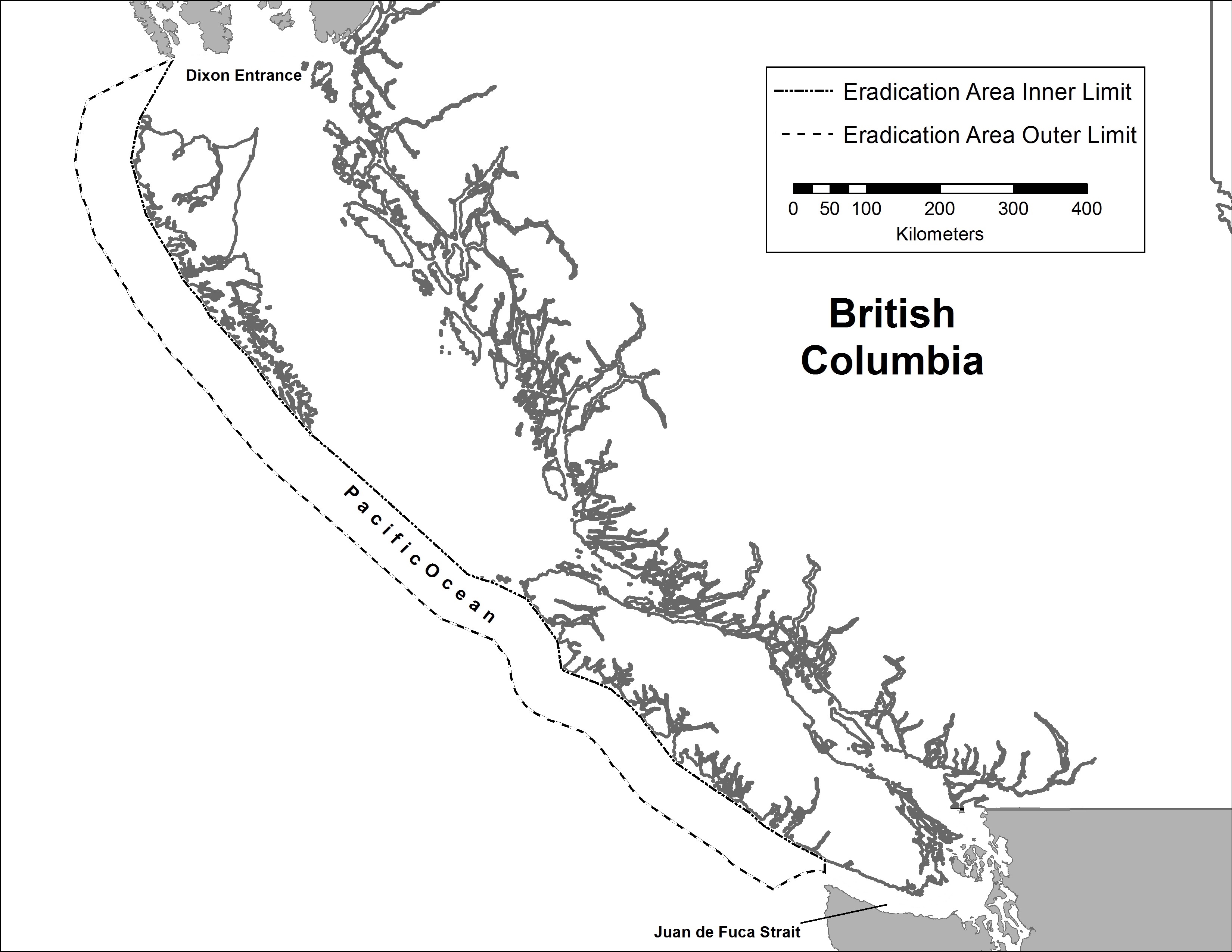
Description of the area identified as Pacific Ocean
The area identified as Pacific Ocean on this map is encompassed by the eradication area inner limit of the territorial sea and the eradication area outer limit of the contiguous zone extending from Dixon Entrance to Juan de Fuca Strait.
Copyright information
© His Majesty the King in Right of Canada, as represented by the Government of Canada, 2025
This product is produced by the Canadian Food Inspection Agency (CFIA) and contains Canadian Hydrographic Service (CHS) data, pursuant to CHS MOU 2025 1118 CFIA.
The CHS boundaries and limits data included in this map should not be relied upon for precise positioning, for example without limiting the generality of the foregoing, for navigation, laying cable or pipelines, mooring, anchoring, dredging, trenching or geographic positioning applications.
This map does not represent an official map of Canadian boundaries, is not authoritative data, and unauthorized redistribution is prohibited.
Pacific Ocean North and Pacific Ocean South – map of the declared areas for molluscan diseases
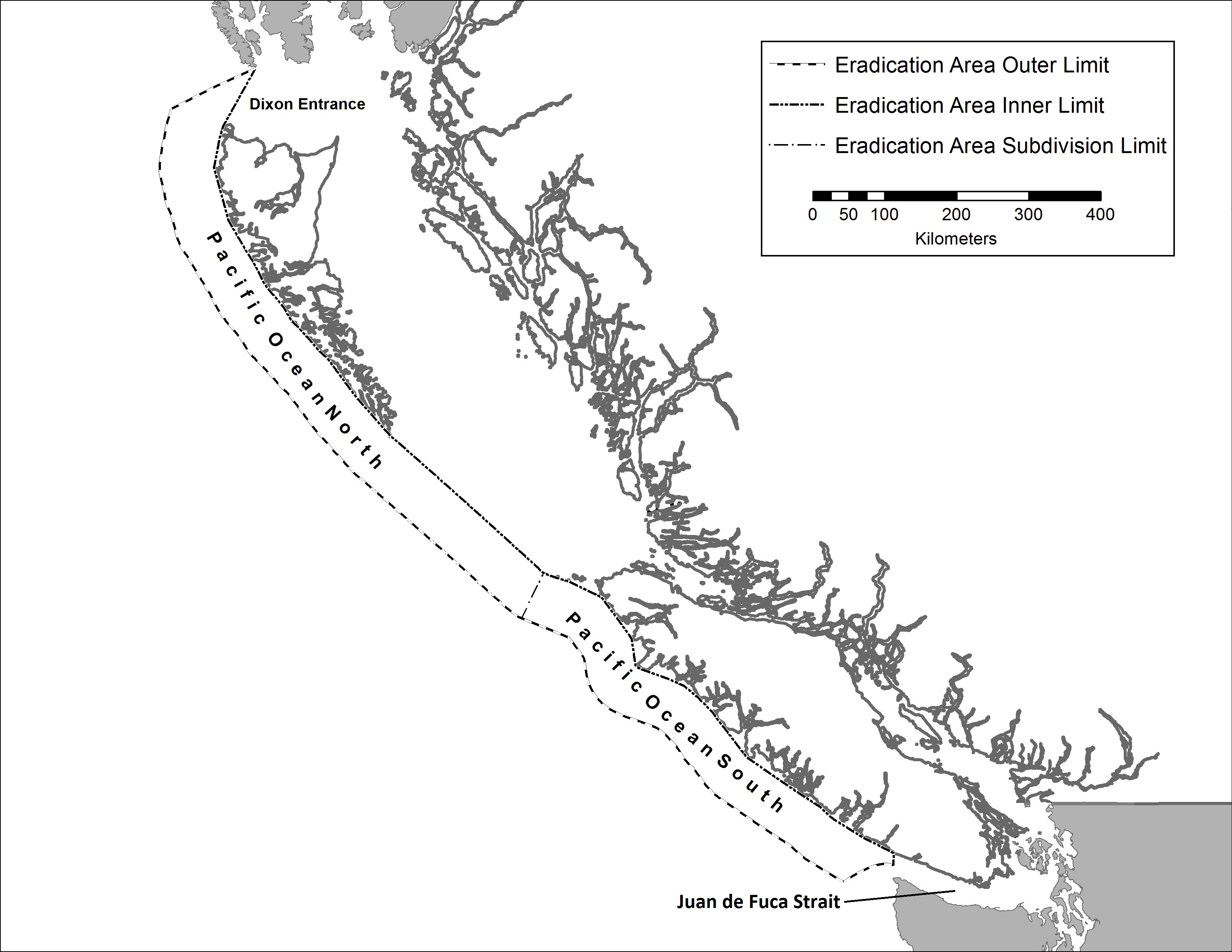
Description for Pacific Ocean North and Pacific Ocean South
The area identified as Pacific Ocean North on the map is encompassed by the eradication area inner limit of the territorial sea and the eradication area outer limit of the contiguous zone extending from Dixon Entrance to the eradication area subdivision limit with the area identified as Pacific Ocean South.
The area identified as Pacific Ocean South on the map is encompassed by the eradication area inner limit of the territorial sea and the eradication area outer limit of the contiguous zone extending from Juan de Fuca Strait to the eradication area subdivision limit with the area identified as Pacific Ocean North.
Copyright information
© His Majesty the King in Right of Canada, as represented by the Government of Canada, 2025
This product is produced by the Canadian Food Inspection Agency (CFIA) and contains Canadian Hydrographic Service (CHS) data, pursuant to CHS MOU 2025 1118 CFIA.
The CHS boundaries and limits data included in this map should not be relied upon for precise positioning, for example without limiting the generality of the foregoing, for navigation, laying cable or pipelines, mooring, anchoring, dredging, trenching or geographic positioning applications.
This map does not represent an official map of Canadian boundaries, is not authoritative data, and unauthorized redistribution is prohibited.
British Columbia – map of the declared areas for finfish diseases
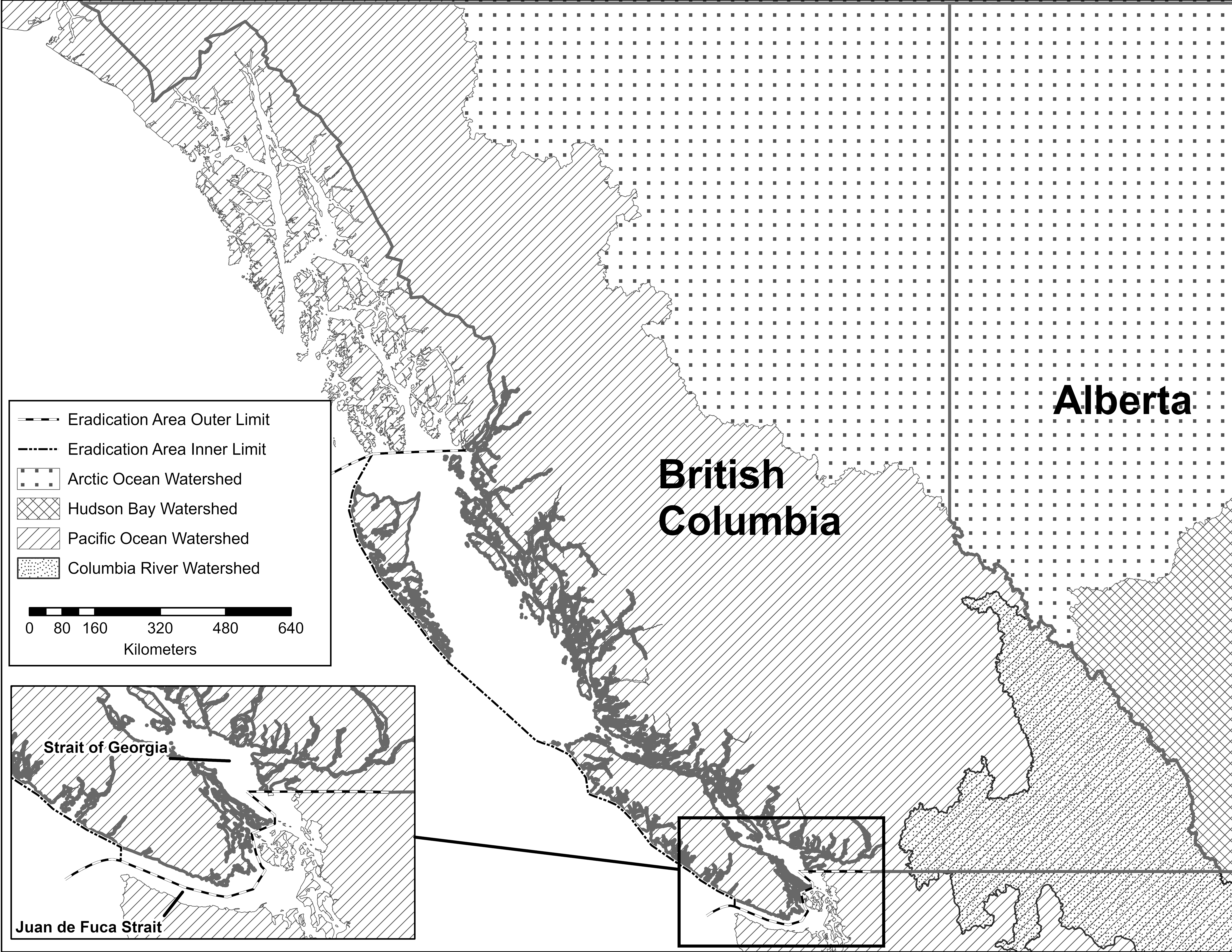
Description of the areas for British Columbia
The area identified as British Columbia on the map is the entire province of British Columbia described by its geopolitical boundaries with Yukon, the Northwest Territories, the province of Alberta, and the United States of America, and includes the internal waters of Canada adjacent to British Columbia encompassed by the eradication area inner limit of the territorial sea and the eradication area outer limit, except for the area described as Columbia River Watershed.
The area identified as Columbia River Watershed on the map is that part of the province of British Columbia where waters drain into the Columbia River encompassed by the province's geopolitical boundaries with the province of Alberta and the United States of America and the watershed boundaries within the province of British Columbia that delineates the watershed of the Columbia River.
The area identified as Arctic Ocean Watershed on the map is that part of the province of British Columbia where the waters drain into the Arctic Ocean encompassed by the province's geopolitical boundaries with Yukon, the Northwest Territories and the province of Alberta, and the watershed boundary within the province of British Columbia that separates the Arctic Ocean Watershed from the Pacific Ocean Watershed.
The area identified as Pacific Ocean Watershed on the map is that part of the province of British Columbia where the waters drain into the Pacific Ocean encompassed by the province's geopolitical boundaries with Yukon, the province of Alberta and the United States of America, and the watershed boundary within the province of British Columbia that separates the Pacific Ocean Watershed from the Arctic Ocean Watershed, and includes the internal waters of Canada adjacent to British Columbia encompassed by the eradication area inner limit of the territorial sea and eradication area outer limit.
Copyright information
© His Majesty the King in Right of Canada, as represented by the Government of Canada, 2025
This product is produced by the Canadian Food Inspection Agency (CFIA) and contains Canadian Hydrographic Service (CHS) data, pursuant to CHS MOU 2025 1118 CFIA.
The CHS boundaries and limits data included in this map should not be relied upon for precise positioning, for example without limiting the generality of the foregoing, for navigation, laying cable or pipelines, mooring, anchoring, dredging, trenching or geographic positioning applications.
This map does not represent an official map of Canadian boundaries, is not authoritative data, and unauthorized redistribution is prohibited.
British Columbia North – map of the declared area for molluscan diseases
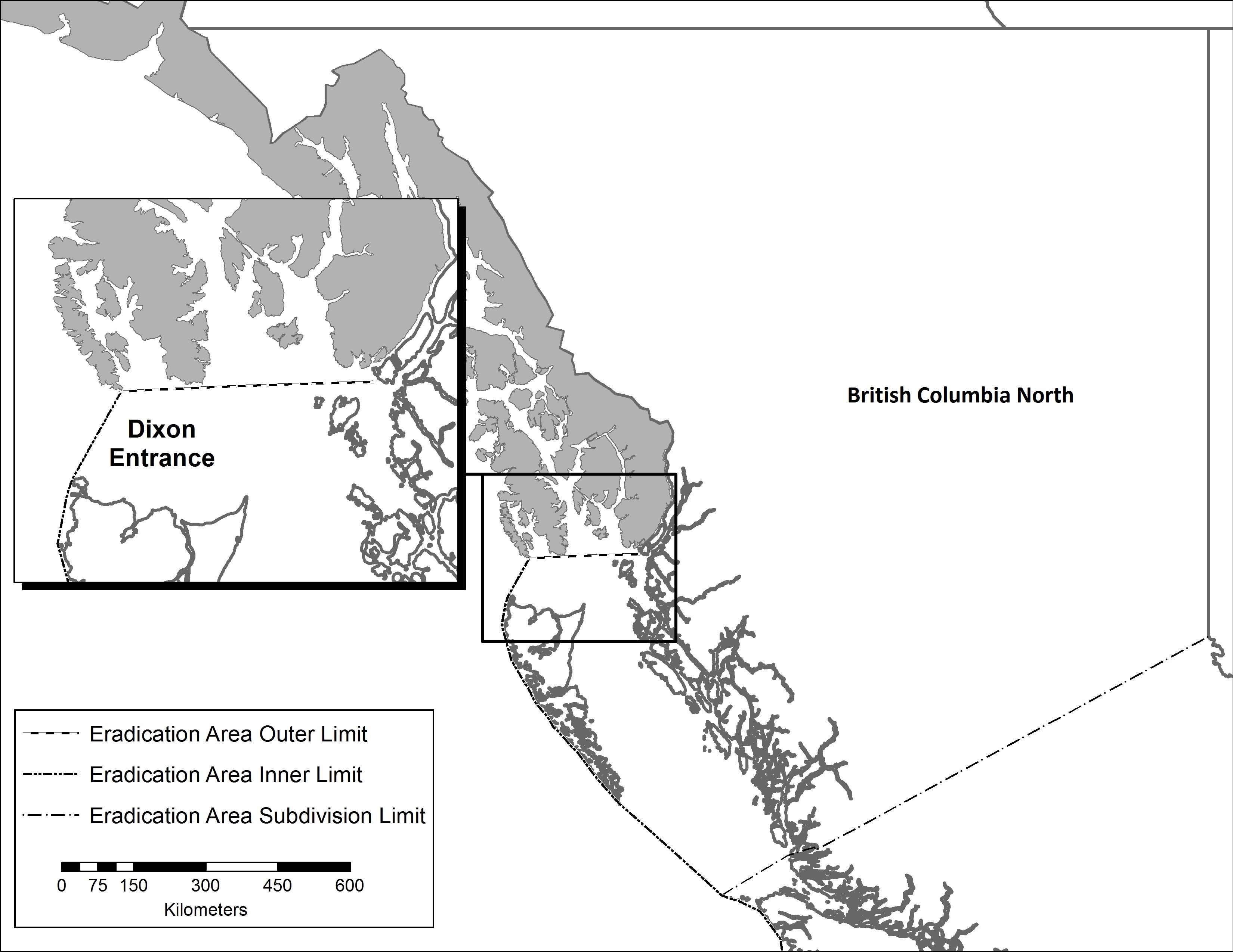
Description for the area identified as British Columbia North
The area identified as British Columbia North on this map is the northern part of the province of British Columbia described by its geopolitical boundaries with Yukon, the Northwest Territories, the province of Alberta and the United States of America, and the eradication area subdivision limit that extends from the eradication area inner limit of the territorial sea to the boundary with the province of Alberta, and includes the internal waters of Canada adjacent to British Columbia North encompassed by the eradication area inner limit of the territorial sea, eradication area subdivision limit and eradication area outer limit.
Copyright information
© His Majesty the King in Right of Canada, as represented by the Government of Canada, 2025
This product is produced by the Canadian Food Inspection Agency (CFIA) and contains Canadian Hydrographic Service (CHS) data, pursuant to CHS MOU 2025 1118 CFIA.
The CHS boundaries and limits data included in this map should not be relied upon for precise positioning, for example without limiting the generality of the foregoing, for navigation, laying cable or pipelines, mooring, anchoring, dredging, trenching or geographic positioning applications.
This map does not represent an official map of Canadian boundaries, is not authoritative data, and unauthorized redistribution is prohibited.
British Columbia South – map of the declared area for molluscan diseases
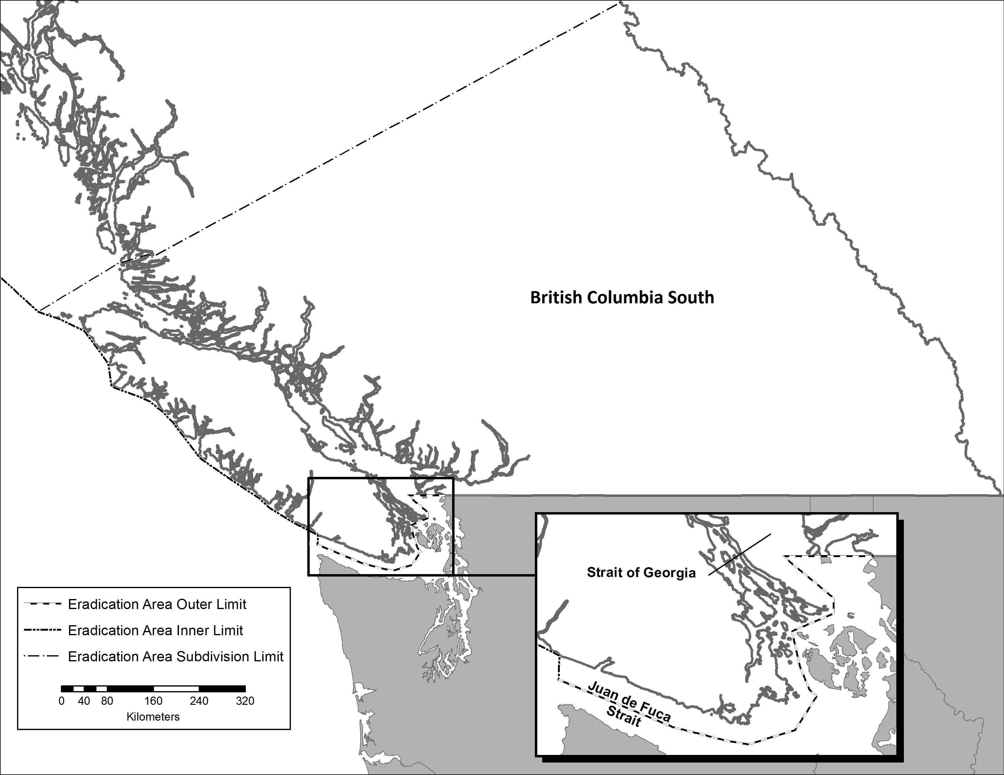
Description for the area identified as British Columbia South
The area identified as British Columbia South on this map is the southern part of the province of British Columbia described by its geopolitical boundaries with the province of Alberta and the United States of America, and the eradication area subdivision limit that extends from the eradication area inner limit of the territorial sea to the boundary with the province of Alberta, and includes the internal waters of Canada adjacent to British Columbia South encompassed by the eradication area inner limit of the territorial sea, eradication area subdivision limit and eradication area outer limit.
Copyright information
© His Majesty the King in Right of Canada, as represented by the Government of Canada, 2025
This product is produced by the Canadian Food Inspection Agency (CFIA) and contains Canadian Hydrographic Service (CHS) data, pursuant to CHS MOU 2025 1118 CFIA.
The CHS boundaries and limits data included in this map should not be relied upon for precise positioning, for example without limiting the generality of the foregoing, for navigation, laying cable or pipelines, mooring, anchoring, dredging, trenching or geographic positioning applications.
This map does not represent an official map of Canadian boundaries, is not authoritative data, and unauthorized redistribution is prohibited.
Yukon – map of the declared areas for finfish diseases
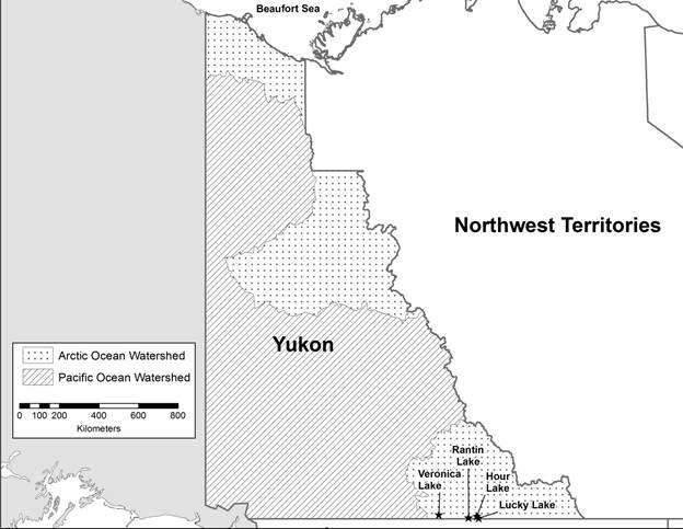
Description of the areas for Yukon
The area identified as Yukon on the map is the entire territory of Yukon described by its geopolitical boundaries with the province of British Columbia, the Northwest Territories and the United States of America to the lowest tide mark in the Beaufort Sea as described in the official publication of the Canadian Tide and Current Tables.
The area identified as Arctic Ocean Watershed on the map is that part of the territory of Yukon where waters drain into the Arctic Ocean encompassed by the territory's geopolitical boundaries with the Northwest Territories, the province of British Columbia, and the United States of America, and the watershed boundary within the territory of Yukon that separates the Arctic Ocean Watershed from the Pacific Ocean Watershed to the lowest tide mark in the Beaufort Sea as described in the official publication of the Canadian Tide and Current Tables.
The area identified as Pacific Ocean Watershed on the map is that part of the territory of Yukon where waters drain into the Pacific Ocean and Bering Sea encompassed by the territory's geopolitical boundaries with the Northwest Territories, the province of British Columbia, and the United States of America, and the watershed boundary within the territory of Yukon that separates the Pacific Ocean Watershed from the Arctic Ocean Watershed.
The area identified as Hour Lake on the map is the entire lake described by its global positioning system (GPS) coordinates that approximates the position of the middle of the lake: latitude 60.0560, longitude -128.6624.
The area identified as Lucky Lake on the map is the entire lake described by its global positioning system (GPS) coordinates that approximates the position of the middle of the lake: latitude 60.0169, longitude -128.5813.
The area identified as Rantin Lake on the map is the entire lake described by its global positioning system (GPS) coordinates that approximates the position of the middle of the lake: latitude 60.0263, longitude -129.0382.
The area identified as Veronica Lake on the map is the entire lake described by its global positioning system (GPS) coordinates that approximates the position of the middle of the lake: latitude 60.0886, longitude -130.3970.
Copyright information
© His Majesty the King in Right of Canada, as represented by the Government of Canada, 2025
This product is produced by the Canadian Food Inspection Agency (CFIA) and contains Canadian Hydrographic Service (CHS) data, pursuant to CHS MOU 2025 1118 CFIA.
The CHS boundaries and limits data included in this map should not be relied upon for precise positioning, for example without limiting the generality of the foregoing, for navigation, laying cable or pipelines, mooring, anchoring, dredging, trenching or geographic positioning applications.
This map does not represent an official map of Canadian boundaries, is not authoritative data, and unauthorized redistribution is prohibited.
Alberta – map of the declared areas for finfish diseases
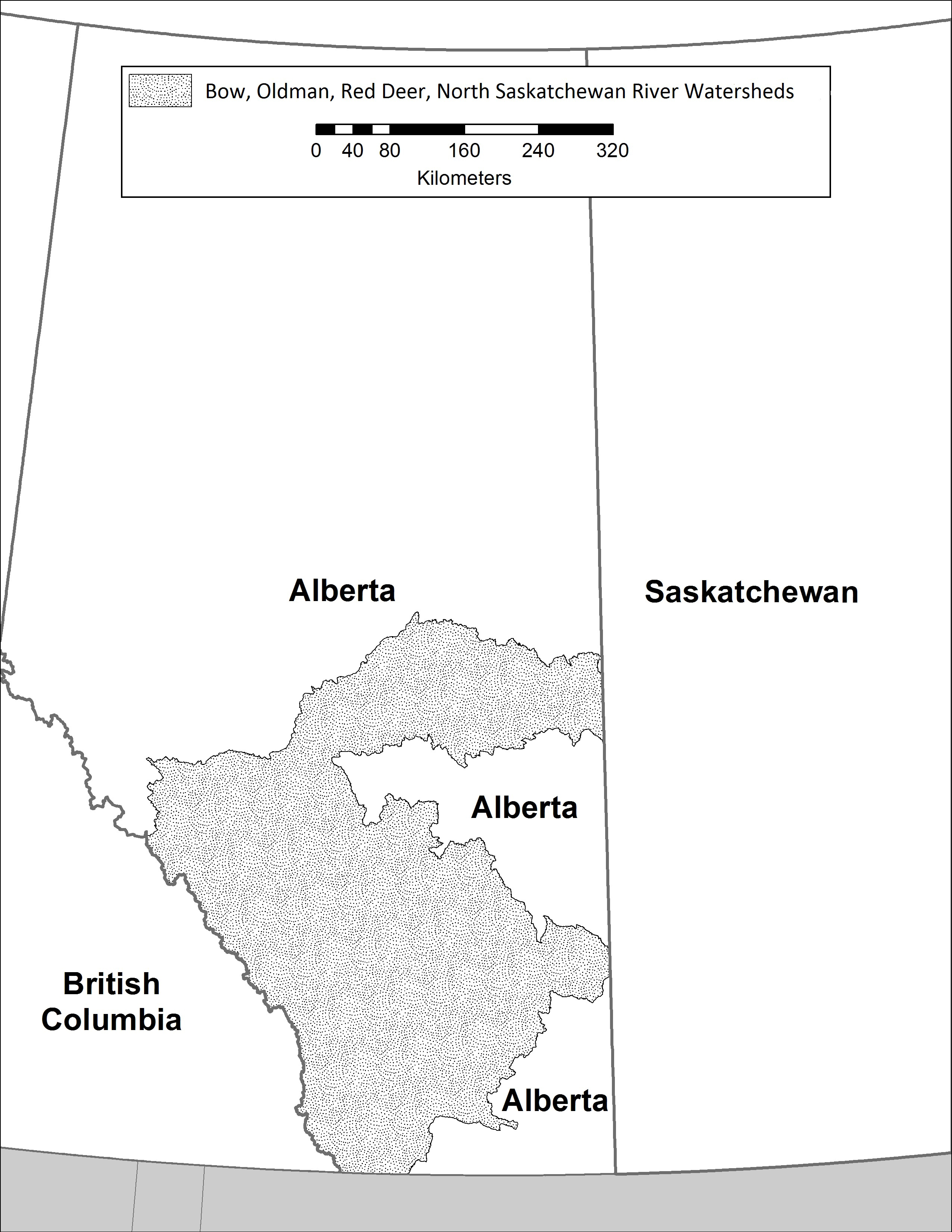
Description of the areas for Alberta
The areas identified as Alberta on the map is the entire province of Alberta described by its geopolitical boundaries with the provinces of British Columbia and Saskatchewan, the Northwest Territories and the United States of America, except for the area described as Bow, Oldman Red Deer, North Saskatchewan River Watersheds.
The area identified as Bow, Oldman, Red Deer, North Saskatchewan River Watersheds on the map is that part of the province of Alberta where waters drain into the Bow River, Oldman River, Red Deer River, and North Saskatchewan River encompassed by the province's geopolitical boundaries with the provinces of British Columbia and Saskatchewan and the United States of America and the watershed boundaries within the province of Alberta that delineates the watersheds of the Bow River, Oldman River, Red Deer River and North Saskatchewan River but excludes the Battle River watershed.
Copyright information
© His Majesty the King in Right of Canada, as represented by the Government of Canada, 2025
This product is produced by the Canadian Food Inspection Agency (CFIA) and contains Canadian Hydrographic Service (CHS) data, pursuant to CHS MOU 2025 1118 CFIA.
The CHS boundaries and limits data included in this map should not be relied upon for precise positioning, for example without limiting the generality of the foregoing, for navigation, laying cable or pipelines, mooring, anchoring, dredging, trenching or geographic positioning applications.
This map does not represent an official map of Canadian boundaries, is not authoritative data, and unauthorized redistribution is prohibited.
Ontario – map of the declared areas for finfish diseases
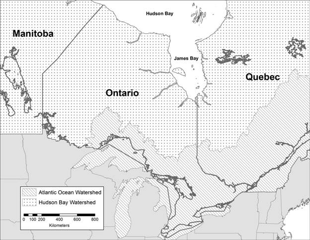
Description of the areas for Ontario
The area identified as Ontario on the map is the entire province of Ontario described by its geopolitical boundaries with the provinces of Manitoba and Quebec and with the United States of America to the lowest tide mark in Hudson Bay and James Bay as described in the official publication of the Canadian Tide and Current Tables.
The area identified as Hudson Bay Watershed on the map is that part of the province of Ontario where waters drain into Hudson Bay encompassed by the province's geopolitical boundaries with the provinces of Manitoba and Quebec and the watershed boundary within the province of Ontario that separates the Hudson Bay Watershed from the Atlantic Ocean Watershed to the lowest tide mark in Hudson Bay and James Bay as described in the official publication of the Canadian Tide and Current Tables.
The area identified as Atlantic Ocean Watershed on the map is that part of the province of Ontario where waters drain into the Atlantic Ocean encompassed by the province's geopolitical boundaries with the provinces of Manitoba and Quebec and the United States of America and the watershed boundary within the province of Ontario that separates the Atlantic Ocean Watershed from the Hudson Bay Watershed.
Copyright information
© His Majesty the King in Right of Canada, as represented by the Government of Canada, 2025
This product is produced by the Canadian Food Inspection Agency (CFIA) and contains Canadian Hydrographic Service (CHS) data, pursuant to CHS MOU 2025 1118 CFIA.
The CHS boundaries and limits data included in this map should not be relied upon for precise positioning, for example without limiting the generality of the foregoing, for navigation, laying cable or pipelines, mooring, anchoring, dredging, trenching or geographic positioning applications.
This map does not represent an official map of Canadian boundaries, is not authoritative data, and unauthorized redistribution is prohibited.
Quebec – map of the declared area for finfish and molluscan diseases
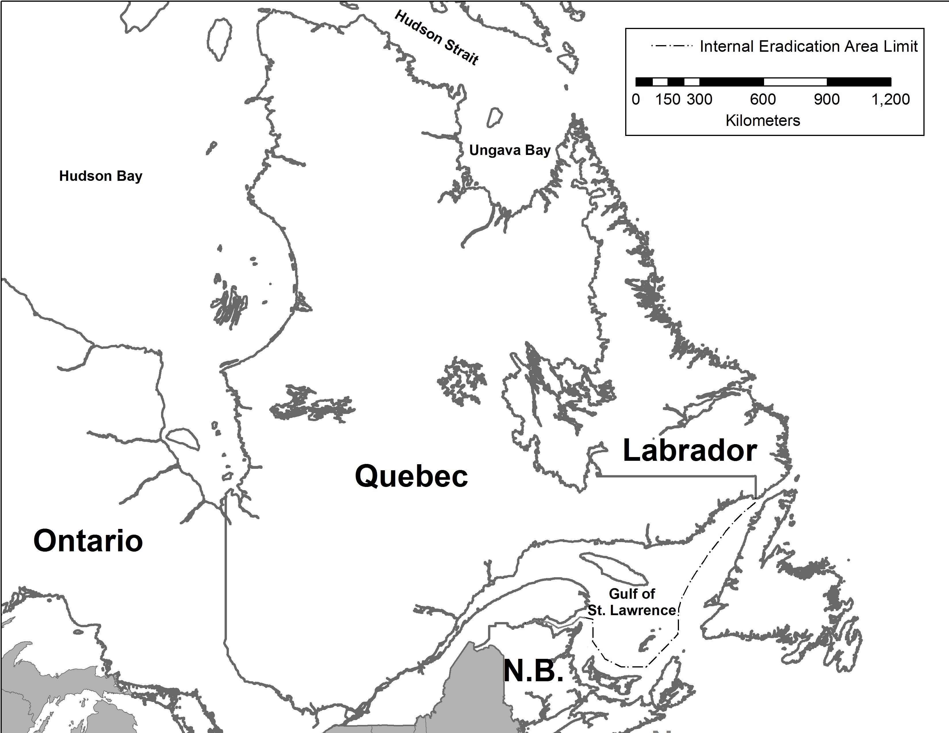
Description for the area identified as Quebec
The area identified as Quebec on the map is the entire province of Quebec described by its geopolitical boundaries with the provinces of Ontario, New Brunswick and Newfoundland and Labrador and with the United States of America to the lowest tide mark in Hudson Bay, Hudson Strait and Ungava Bay as described in the official publication of the Canadian Tide and Current Tables, and includes the internal waters of Canada in the Gulf of St. Lawrence encompassed by the internal eradication area limit extending from the provincial boundary of Quebec with New Brunswick to the provincial boundary of Quebec with Labrador.
Copyright information
© His Majesty the King in Right of Canada, as represented by the Government of Canada, 2025
This product is produced by the Canadian Food Inspection Agency (CFIA) and contains Canadian Hydrographic Service (CHS) data, pursuant to CHS MOU 2025 1118 CFIA.
The CHS boundaries and limits data included in this map should not be relied upon for precise positioning, for example without limiting the generality of the foregoing, for navigation, laying cable or pipelines, mooring, anchoring, dredging, trenching or geographic positioning applications.
This map does not represent an official map of Canadian boundaries, is not authoritative data, and unauthorized redistribution is prohibited.
New Brunswick – map of the declared area for finfish and molluscan diseases
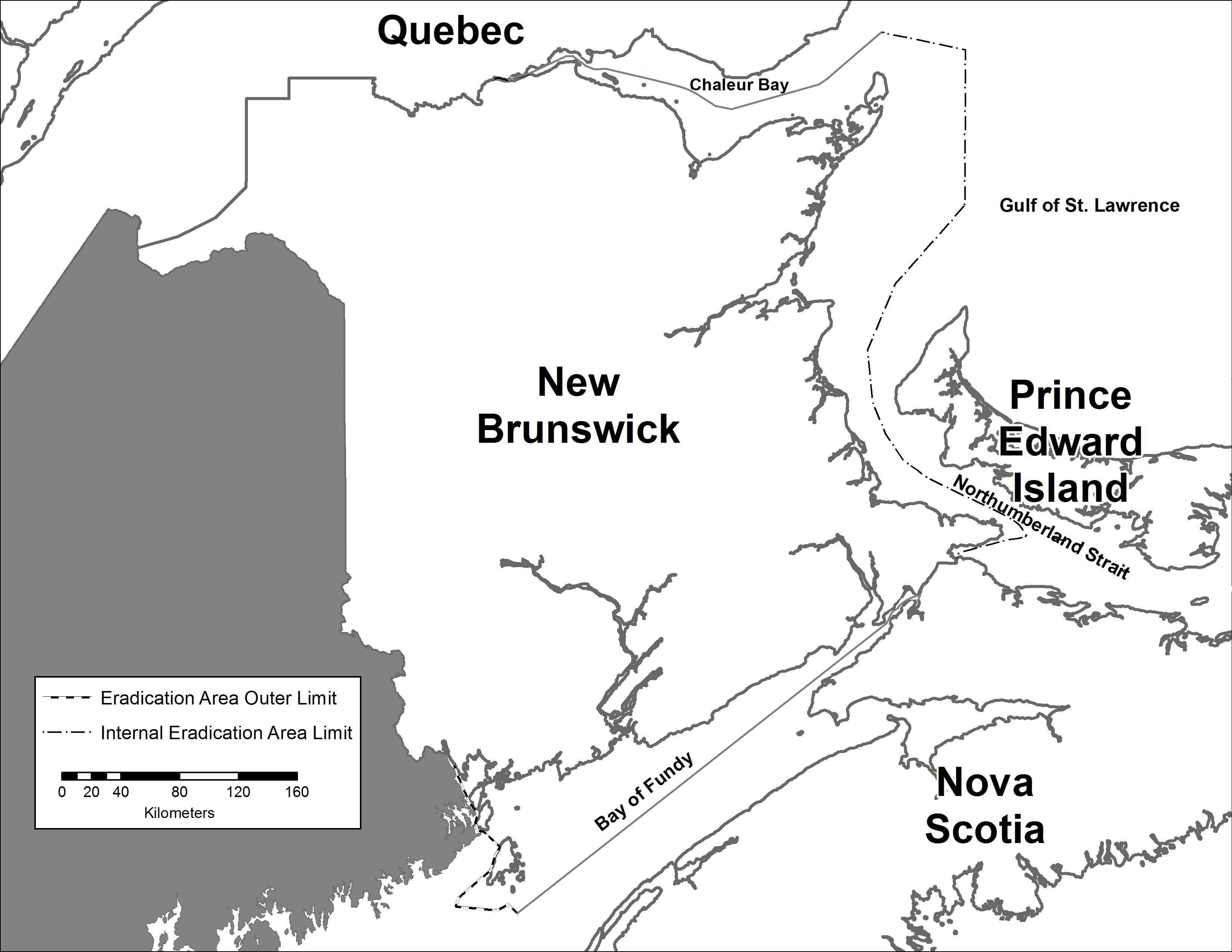
Description for the area identified as New Brunswick
The area identified as New Brunswick on the map is the entire province of New Brunswick described by its geopolitical boundaries with the provinces of Quebec and Nova Scotia and with the United States of America, and includes the internal waters of Canada adjacent to the province of New Brunswick in Chaleur Bay, the Gulf of St. Lawrence and Northumberland Strait encompassed by the provincial boundary with Quebec and the internal eradication area limit extending from the provincial boundary with Quebec to the provincial boundary with Nova Scotia, and the internal waters of Canada in the Bay of Fundy encompassed by the provincial boundary with Nova Scotia and the eradication area outer limit.
Copyright information
© His Majesty the King in Right of Canada, as represented by the Government of Canada, 2025
This product is produced by the Canadian Food Inspection Agency (CFIA) and contains Canadian Hydrographic Service (CHS) data, pursuant to CHS MOU 2025 1118 CFIA.
The CHS boundaries and limits data included in this map should not be relied upon for precise positioning, for example without limiting the generality of the foregoing, for navigation, laying cable or pipelines, mooring, anchoring, dredging, trenching or geographic positioning applications.
This map does not represent an official map of Canadian boundaries, is not authoritative data, and unauthorized redistribution is prohibited.
Prince Edward Island – map of the declared area for finfish and molluscan diseases

Description for the area identified as Prince Edward Island
The area identified as Prince Edward Island on the map is the entire province of Prince Edward Island including the internal waters of Canada adjacent to Prince Edward Island in the Gulf of St. Lawrence and Northumberland Strait that is encompassed by the internal eradication area limit.
Copyright information
© His Majesty the King in Right of Canada, as represented by the Government of Canada, 2025
This product is produced by the Canadian Food Inspection Agency (CFIA) and contains Canadian Hydrographic Service (CHS) data, pursuant to CHS MOU 2025 1118 CFIA.
The CHS boundaries and limits data included in this map should not be relied upon for precise positioning, for example without limiting the generality of the foregoing, for navigation, laying cable or pipelines, mooring, anchoring, dredging, trenching or geographic positioning applications.
This map does not represent an official map of Canadian boundaries, is not authoritative data, and unauthorized redistribution is prohibited.
Nova Scotia – map of the declared area for finfish and molluscan diseases
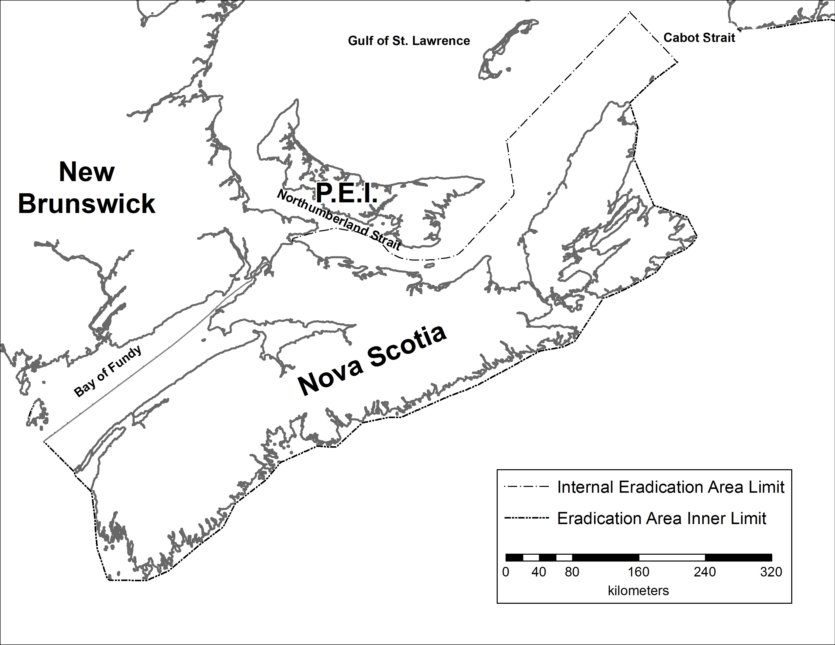
Description for the area identified as Nova Scotia
The area identified as Nova Scotia on the map is the entire province of Nova Scotia described by its geopolitical boundary with the province of New Brunswick and includes the internal waters of Canada adjacent to Nova Scotia encompassed by the provincial boundary with New Brunswick in the Bay of Fundy, the eradication area inner limit of the territorial sea in the Atlantic Ocean and the internal eradication area limit extending from the eradication area inner limit through Cabot Strait, Gulf of St. Lawrence and Northumberland Strait to the provincial boundary with New Brunswick.
Copyright information
© His Majesty the King in Right of Canada, as represented by the Government of Canada, 2025
This product is produced by the Canadian Food Inspection Agency (CFIA) and contains Canadian Hydrographic Service (CHS) data, pursuant to CHS MOU 2025 1118 CFIA.
The CHS boundaries and limits data included in this map should not be relied upon for precise positioning, for example without limiting the generality of the foregoing, for navigation, laying cable or pipelines, mooring, anchoring, dredging, trenching or geographic positioning applications.
This map does not represent an official map of Canadian boundaries, is not authoritative data, and unauthorized redistribution is prohibited.
Newfoundland and Labrador – map of the declared area for finfish and molluscan diseases
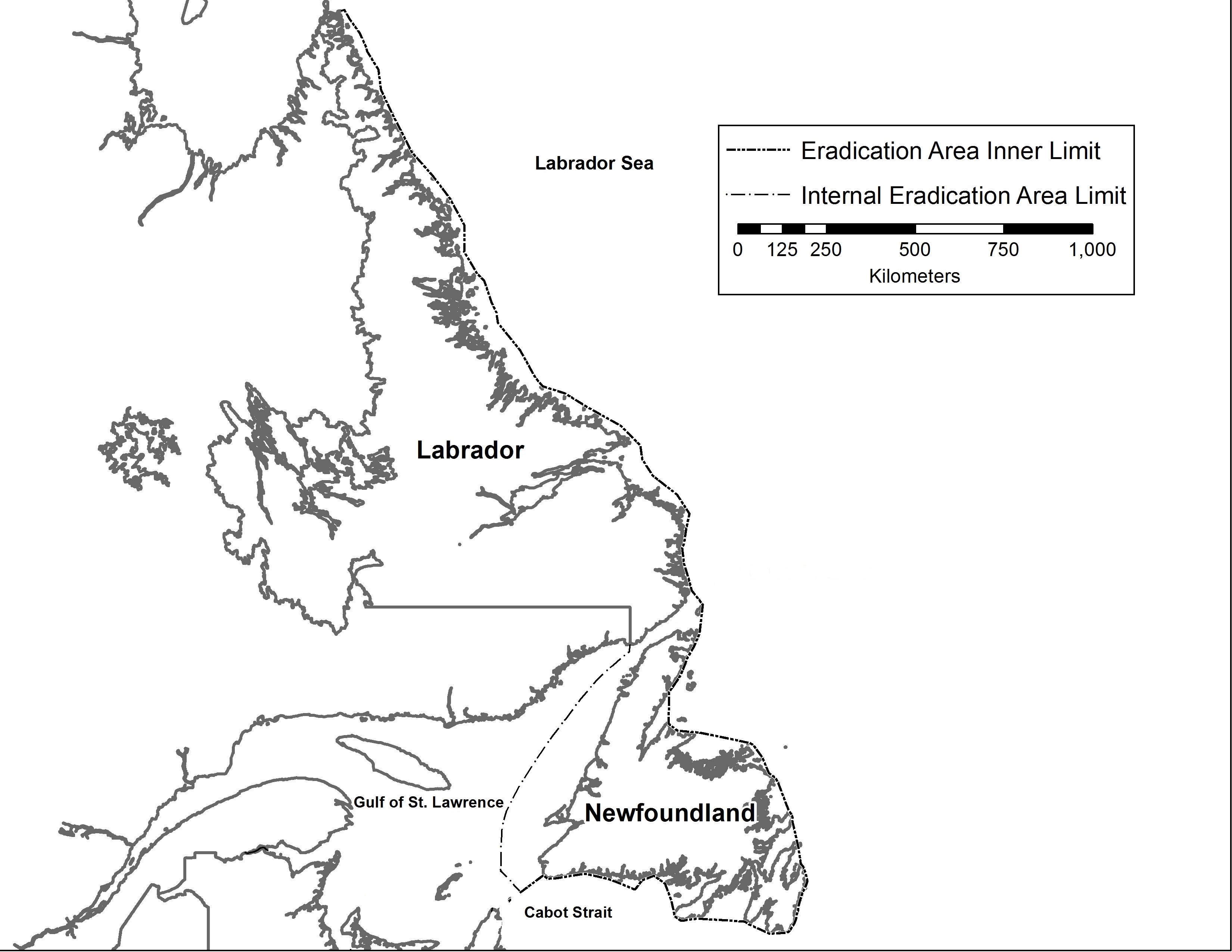
Description for the area identified as Newfoundland and Labrador
The area identified as Newfoundland and Labrador on the map is the entire province of Newfoundland and Labrador described by its geopolitical boundaries with the province of Quebec and the territory of Nunavut, and includes the internal waters of Canada adjacent to the province encompassed by the eradication area inner limit of the territorial sea in the Atlantic Ocean and the internal eradication area limit extending from the eradication area inner limit through Cabot Strait and the Gulf of St. Lawrence to the provincial boundary of Labrador with Quebec.
Copyright information
© His Majesty the King in Right of Canada, as represented by the Government of Canada, 2025
This product is produced by the Canadian Food Inspection Agency (CFIA) and contains Canadian Hydrographic Service (CHS) data, pursuant to CHS MOU 2025 1118 CFIA.
The CHS boundaries and limits data included in this map should not be relied upon for precise positioning, for example without limiting the generality of the foregoing, for navigation, laying cable or pipelines, mooring, anchoring, dredging, trenching or geographic positioning applications.
This map does not represent an official map of Canadian boundaries, is not authoritative data, and unauthorized redistribution is prohibited.
Atlantic Ocean – map of the declared area for finfish and molluscan diseases

Description for the area identified as Atlantic Ocean
The area identified as Atlantic Ocean on this map is encompassed by the eradication area inner limit of the territorial sea and the eradication area outer limit of the contiguous zone extending from the Bay of Fundy into the Labrador Sea to the limit adjacent to the northern extent of Labrador.
Copyright information
© His Majesty the King in Right of Canada, as represented by the Government of Canada, 2025
This product is produced by the Canadian Food Inspection Agency (CFIA) and contains Canadian Hydrographic Service (CHS) data, pursuant to CHS MOU 2025 1118 CFIA.
The CHS boundaries and limits data included in this map should not be relied upon for precise positioning, for example without limiting the generality of the foregoing, for navigation, laying cable or pipelines, mooring, anchoring, dredging, trenching or geographic positioning applications.
This map does not represent an official map of Canadian boundaries, is not authoritative data, and unauthorized redistribution is prohibited.